Some of my journal entries were pretty long. I packed a lot into this day and when I reached the campsite at Cypress Hills Interprovincial Park I filled many pages with my thoughts. Because of this I'm going to break the day into three parts.
June 12, 2006Ah, to be blessed with a landscape like Alberta's. That is if you are in the business of building and maintaining a highway system. The best highways on my entire trip were in Alberta. Many are divided highways with wide shoulders that run straight for as far as the eye can see. The flatness of the prairie makes it hard to judge scale. A problem not limited just to distance, but also to speed. On more than one occasion I looked down and saw the needle on the speedometer creeping into the 150 kilometre an hour zone, and beyond. Even the gravel roads were better maintained and easier to drive than some of the secondary roads in other provinces - Saskatchewan had scary roads.
travelled 424km today/1758km total.
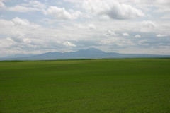
I left Lethbridge around 10a.m., heading south-east toward Milk River. About 30 minutes outside Lethbridge, just north of Warner, I came over a rise and far to the south, blue in the haze, I saw a mountain. I thought it might be my first glimpse of the Cypress Hills, but the direction was wrong and it seemed to soon in my trip. It was a remarkable sight to see: this lump thrusting up out of the flat prairies and into the clouds, with a central peak shaped like a ziggurat
The Sweetgrass Hills of Montana.
Twenty minutes later I was in Milk River where I learned I had been driving toward the Sweetgrass Hills in Montana. The Blackfoot name is Sweetgrass Mountains but apparently something got lost in translation. No biggy. Still later, when I was at Writing on Stone Provincial Park(which I'll get to in a moment,) I was told there actually very little sweetgrass in the area.
Milk River is just a few kilometres north of the border with the United States. I stopped in at the information centre where I spoke with William. In his 20's, William was from the area. His grandfather was a homesteader who moved to the area from Minnesota during the early 1900's. He said many of the early homesteaders were from around Minnesota as well as from Utah. The mormon population of the region is sizeable.
William has a farm a little ways away where he grows durham wheat. Durham is the dominant crop grown in the area, along with some mustard and a spattering of canola. He said there was a lot of canola grown until about 15 years ago, when Monsanto moved in. "A lot of farmers lost their shirts," he said and it just isn't grown anymore.
The mouse and gopher population seems healthy. There are an awful lot of hawks dining near the highway. Yesterday I watched one swoop down to the median, brake hard, then flap like mad back into the sky with a furry little critter twitching in its talons. Swift death from the sky.
At Milk River I turned east. It was here, along route 501, that I saw a badger scuttle across the highway. I learned later that badgers are nocturnal animals and a daylight sighting was rare. I'm just glad I didn't hit it. Low, sleek and built with a neck like a pitbull it hugged the highway as it crossed just metres in front of the car. I'm not sure what damage it would have done had we met tire to fur.
No comments:
Post a Comment